
Species traits assessment to monitor tree health condition over open MEDiterranean forest ecosystems for a Hyperspectral imager


, San Joaquin Experimental Range, CA, USA")


, Tonzi Ranch, CA, USA")
, Tonzi Ranch, CA, USA")
SCOPE & OBJECTIVES
The HyperMED project focuses on the study of woodland savannas in Mediterranean climate. In presence of pasture grazing, they are represented by tree-grass ecosystems having a limited number of endemic species, some of them being fire-tolerant. They are becoming critical areas due to agriculture and urbanization expansion, and abnormal increase of droughts and forest fires.
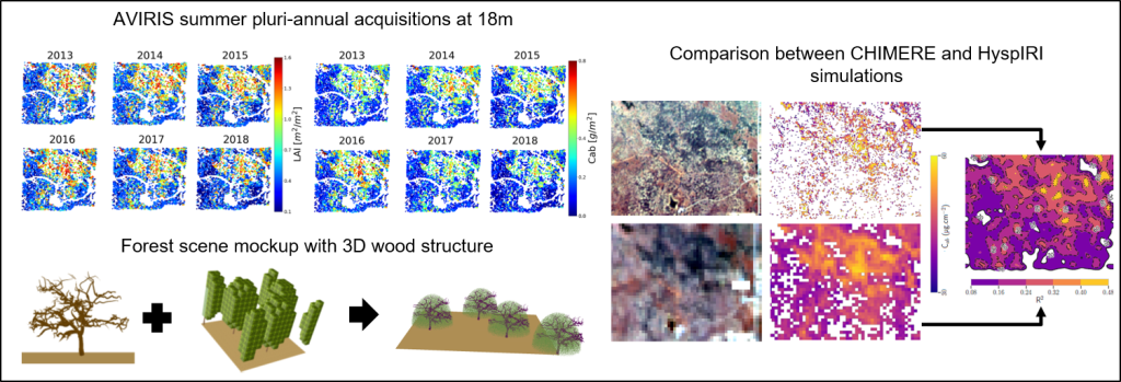
The objective is to demonstrate the ability of two hyperspectral satellite missions, CNES-CHIMERE and NASA-HyspIRI, to estimate and monitor over time vegetation biophysical and biochemical variables (namely LAI: Leaf Area Index, CHL: CHLorophylls, CAR: CARotenoids, EWT: Equivalent Water Thickness, LMA: Leaf Mass Area) as species traits able to witness the plant health condition or physiological processes such as photosynthesis, transpiration, nutrient allocation, growth rate and decomposition. Their accurate estimation requires a good signal-to-noise ratio (especially for CAR having a narrow sensitivity spectral range), a spatial resolution adapted to the ecosystem specificities (e.g. limitations due to the large encountered range of canopy covers), and an appropriate temporal revisit to follow their seasonal and interannual variability (i.e. phenological cycles). CHIMERE and HyspIRI sensors may be complementary to deal with this issues since they have different spatial resolution (CHIMERE at 8m targeting the tree scale, HyspIRI at 30m observing a larger and more diverse scenery), same spectral characteristics (hyperspectral 0.4-2.5 µm with 10nm resolution) but different signal-to-noise ratio (CHIMERE’s lower to HyspIRI’s).
DATA & METHODS
Two grass-oak-pine woodland savannas are studied, Tonzi Ranch (TZ) and San Joaquin Experimental Range (SJER), located on the foothills of the Sierra Nevada mountain range in California. They both have a cattle grazing activity. TZ is a private owned land and carry instrumentation platforms managed by Biomet Lab, some included in the Ameriflux/Fluxnet and Phenocam networks. SJER is hosted by the U.S. Forest Service where NEON (National Ecological Observatory Network) established one of their terrestrial site for further samplings and observations. TZ and SJER are reference sites for the HyspIRI mission. The two studied broadleaf oak tree species are Quercus Douglasii (deciduous) and Quercus Wislizeni (evergreen).
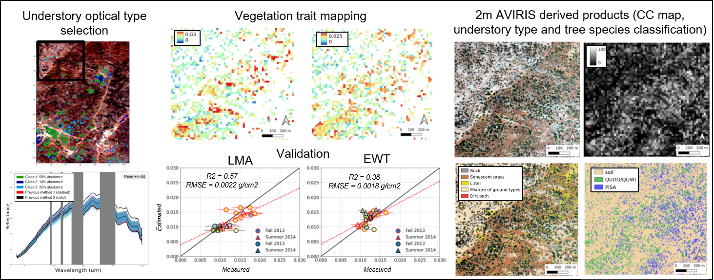
The complete used dataset includes species trait measurements in the field and laboratory performed by CSTARS as part of NASA-ROSES project and AVIRIS-Classic/Next Generation hyperspectral airborne acquisitions at 2m and at 18m performed by NASA JPL from which were simulated CHIMERE and HyspIRI images.
The general methodology relies on the development of a hybrid inversion method based on simulated spectral databases or LUT (Look-Up-Table) from leaf (PROSPECT) and canopy (DART) radiative transfer models and the building of design of experiments with OpenTURNS python library, and the use of LUT-based or machine learning regression algorithms (MLRA).
RESULTS
For generalization purposes with a minimum of a priori information over the two sites, a simple forest representation was chosen for radiative transfer modeling. Three major criteria impacting the estimation of species traits have been further studied:
1) the tree canopy cover (CC)
For the most open areas of the forest (i.e. having low CC), the challenge is to be able to extract the spectral features coming from the vegetation low signal that is mixed within a pixel with the high signal contribution of the background. Our work showed that limitations occurred when CC equals or is lower than 10% and that better accuracies are obtained from 30% CC from AVIRIS at 18m. These findings were confirmed with the creation of PROSAIL2DART (approximation of the 3D DART model by the 1D PROSAIL model) which showed the highest non linear adequation below 30% CC, especially for blue, red and short-wave infrared regions.

2) the proportion and 3D structure of tree woody elements
Due to the low tree LAI of the oaks for both sites, taking into account the presence of wood (e.g. trunk, branches) is important. A very simple modeling composed of a cylindrical trunk proved to be sufficient to estimate accurately LAI and leaf pigments with AVIRIS at 18m, but not for EWT and LMA. Terrestrial LiDAR measurements served to reconstruct the 3D geometry of woody elements. Adding the latter in the generation of a synthetic forest scene mock-up showed that EWT and LMA can be retrieved from AVIRIS at 2m. The upscaling of these results to CHIMERE/HyspIRI, and the comparison with AVIRIS at 18m, demonstrated that the performances to estimate the gap fraction (derived from the combination of CC and LAI) are similar between the three sensors whatever the CC, and also similar for leaf pigments but mostly over the densest canopy areas (CC > 80%). However, more investigations are needed to estimate EWT and LMA.
3) the variability of the understory optical types (e.g. grass and soil)
Previously, a simple image-based vegetation index thresholding was used to set average understory reflectances for scene modeling. Now, an original semi-supervised strategy is built from a spatio-temporal method accounting for seasonal variability to select understory classes and account for their within-class variability. The latter coupled with a simple trunk modeling proved to be more efficient to estimate EWT and LMA compared to the first from AVIRIS at 18m. However, this was to the detriment of bad estimations for leaf pigments.
Prospects are to target a more refined understory/ecosystem modeling through a phenological cycle (PhD of Mathilda Porterie) and study the transferability to other Mediterranean forest sites (SENTHYMED project).
SCIENTIFIC PRODUCTION
Publications
- Miraglio, T., Adeline, K., Huesca, M., Ustin, S., & Briottet, X. (2020a). Monitoring LAI, chlorophylls, and carotenoids content of a woodland savanna using hyperspectral imagery and 3D radiative transfer modeling. Remote Sensing, 12(1), 28.
- Miraglio, T., Adeline, K., Huesca, M., Ustin, S., & Briottet, X. (2020b). Joint use of PROSAIL and DART for fast LUT building: Application to gap fraction and leaf biochemistry estimations over sparse oak stands. Remote sensing, 12(18), 2925.
- Miraglio, T., Huesca, M., Gastellu-Etchegorry, J. P., Schaaf, C., Adeline, K. R., Ustin, S. L., & Briottet, X. (2021). Impact of modeling abstractions when estimating leaf mass per area and equivalent water thickness over sparse forests using a hybrid method. Remote sensing, 13(16), 3235.
- Miraglio, T., Adeline, K., Huesca, M., Ustin, S., & Briottet, X. (2022). Assessing vegetation traits estimates accuracies from the future SBG and biodiversity hyperspectral missions over two Mediterranean Forests. International Journal of Remote Sensing, 43(10), 3537-3562.
Workshops and conferences
- K. Adeline, M. Porterie, R. Demoulin, L. Chauvet, J.-V. Schmitt, T. Miraglio, S. Lefebvre, X. Briottet, J.-P. Gastellu-Etchegorry, C. Schaaf, S. Ustin and D. Baldocchi. Projet HyperMED : estimation des traits fonctionnels de forêts méditerranéennes à canopée ouverte par imagerie hyperspectrale en prévision des missions BIODIVERSITY et SBG. SFPT-GH 8th workshop, 5-6 July 2023, Paris.
- Adeline, K., Miraglio, T., Briottet, X., Gastellu-Etchegorry, J. P., Huesca Martinez, M., Ustin, S., & Baldocchi, D. D. (2019, December). Monitoring Blue Oak Traits in a Woodland Savanna through California Drought by using AVIRIS Imagery from 2013 to 2018. In AGU Fall Meeting Abstracts (Vol. 2019, pp. B23F-2602).
GENERAL INFORMATION
Duration: 2019-2022
Funding: CNES (APR TOSCA)
Principal Investigator: Karine Adeline (ONERA); Co-investigators: Xavier Briottet (ONERA), Jean-Philippe Gastellu-Etchegorry (UPS-CESBIO), Susan Ustin & Margarita huesca (CSTARS, University of California, Davis), Dennis Baldocchi (Biomet Lab, University of California, Berkeley); Other contributors: Sidonie Lefebvre (ONERA), Nicolas Lauret (CNRS-CESBIO), Crystal Schaaf (SpectralMass, University of Massachusetts, Boston), Thomas Miraglio (PhD student), Jean-Victor Schmitt (intern)
Recruited non-permanent staff:
- Louis Chauvet (intern)
- Romain Demoulin (intern)

